Fighting Poverty using Innovative Technology

The Action Research in Community Health and Development (ARCH) has partnered with the Regional Office of the Friedrich Naumann Foundation for Freedom South Asia in empowering marginalized farmers with property rights titles, especially women, by using IT-based methodology to improve their livelihood.
Indians living in rural and forest areas have suffered historic alienation because they were denied their traditional right to property and livelihood. Colonial and post-colonial government policies ensured that they were seen as encroachers on the land that belonged to their forefathers for generations. These communities have consequently lived in the most impoverished conditions, with poor infrastructure and less access to health care.
The Scheduled Tribes and Other Traditional Forest Dwellers (Recognition of Forest Rights) Act, 2006 (FRA), for the first time enabled local population in villages to claim land rights, including community rights to village common resources, such as water and minor forest produce. The land rights could be claimed only if they provided evidence that the land was cultivated by them before 2005.
Their villages and farms were always at risk of demolition by forest departments. The Act was supposed to end this inequity but implementation was terrible. No proper maps or land records existed in most areas. Semi-literate villagers were supposed to fill long forms and file claims. Forest departments contemptuously vetoed most claims.
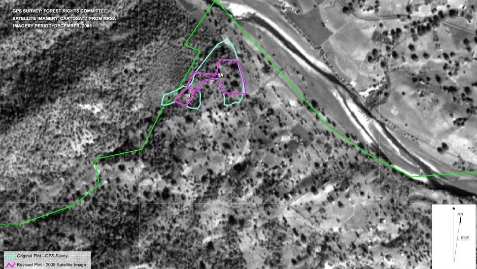
Since 2015 the Regional Office of the Friedrich Naumann Foundation for Freedom South Asia has supported an initiative by Ambrish and Trupti Mehta from ARCH, to document and submit claims regarding private landholdings and village common land to the concerned authorities. The initiative has helped the villagers document their land claims and gather evidence to substantiate their claims for individual title and community forest rights/title by training citizens and the community to read maps, satellite images, and use GPS devices to map the contours of their claimed land area in their villages. The land is first mapped with the help of a GPS device and then superimposed on the satellite image of 2005 from the Google Earth or National Remote Sensing Centre (NRSA). If the mapped land is seen in the satellite image as ‘under cultivation or habitation’, the claim is considered to be correct which is then shown as an evidence to the authorities.

Any encroachment on forest land after 2005 showed up clearly after superimposing today’s maps on the 2005 satellite images, assuaging the Forest Department’s fears.
The title on agricultural land is awarded jointly to the husband and wife, the two adult members of the nuclear family which empowers the woman in the family as well. About 1,83,000 marginalized farmers had filed their claims under the Forest Rights Act, 35,135 of which were approved (registered) through ARCH’s direct and indirect intervention.
Thus, a simple technology provided a quick and elegant solution, ending the dependence of tribal people on government departments or NGOs for land documentation. The project has so far covered 250 tribal villages. There is an urgent need to spread this approach to all forested states and ARCH is trying to do so by contacting NGOs. A massive country-wide effort is needed to empower scheduled tribes and other traditional forest dwellers, making them masters of their own plots and community land.